Exploring The ‘Grand Canyon of Texas’
PALO DURO CANYON — The road to the “Grand Canyon of Texas” from nearby Canyon in the Texas Panhandle is straight as a yardstick while the terrain is so flat that the sky stretches for 180 degrees. It is windy on this late winter day as my Beautiful Mystery Companion and I make our way to the Palo Duro Canyon State Park. It is nearly always windy in the Panhandle, especially this time of year. We pay our $10 entrance fee, tape the receipt to the windshield and enter to discover, a few hundred feet down the road, a vastly different terrain.
We stop at the Interpretive Center, get out, and walk to the edge of the scenic overlook. The second-largest canyon in the United States deserves its title. Palo Duro is 120 miles long and in places as wide as 20 miles, though the average width is six miles. In some places, the canyon is 1,000-feet deep. The walls of the canyon are made up of multi-colored, horizontal striations, created during the Pleistocene era, known to us amateurs as the Ice A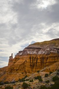 ge.
ge.
The canyon was formed by water erosion, as was its larger counterpart. In this case it is the Prairie Dog Town Fork of the Red River, which is a mouthful of a name for what is now a modest stream. The river is formed north of the canyon it created through the confluence of Palo Duro and Tierra Blanca creeks. The change comes, according to the park website, when the river flows from the Llano Estacado to the Caprock Excarpment, where arroyos and mesas – and the Palo Duro Canyon – formed over millions of years.
We set off to explore. The mid-afternoon light is not great, flattening the canyo
n surfaces as we drive through the park. We cross the Prairie Dog Town Fork of the Red River several times, as clouds skitter above, improving the quality of light by partially obscuring the sun. We stop at the trailhead of a six-mile trek to the canyon’s best-known formation, Lighthouse Rock. I stop often to take photographs, of course, lugging my “real” camera up the trail. My BMC is in her element in the lap of natural beauty. Soon she is far enough ahead of me that after a few bends in the trail, I can’t see her. I start to get a bit nervous and start walking faster. The trail has a few forks in it, and we could end up on separate trails. And there is no cell service this deep inside the canyon.
After a few minutes, I spy her about 100 yards ahead. I whistle, and the sound carries. She stops and I quickly catch up with her. We decide it would be best to stick together.
This trip was taken before Daylight Savings Time returned, so by late afternoon the sun is sinking close to the canyon’s rim. I look at the mile marker. We have only traveled a mile and a quarter on what is supposed to total six miles. “There’s no way we can get up there and back before dark,” I say, and she quickly agrees. Getting stuck in the dark with no water and only our cell-phone flashlights is more adventure than we need these days. We turn around, get back to the trailhead, and finish driving around the park. The light is lovely now, turning the walls an elegant shade of colors.
At the parks’s entrance we stop and park. Three deer are grazing in the median, ignoring all visitors. My BMC spies two longhorn steer inside a pen, one grazing on a pile of hay, the other peering from behind some brush. The steers were brought in to commemorate the time when Palo Duro Canyon was part of cattle rancher Charles Goodnight’s empire. The rangy longhorns can survive on less-than-lush vegetation and proved perfect for this region. My BMC hollers and waves at the steer, trying to get him to look up for a better photo. The steer is having none of it, its nose buried in the hay.
The wind is starting to kick up as we get back in the car for the short trip back to Canyon.
Leave a reply
Fields marked with * are required


